
Floods | ENVIRONMENTAL GEOGRAPHY Optional for UPSC
Floods | ENVIRONMENTAL GEOGRAPHY Optional for UPSC

- It is a Cumulative Atmospheric Hazards, which occurs due to unequal spatial and temporal distribution of rainfall.
- Flood is the inundation of a land area, when water escapes its usual levees or boundaries, from water bodies, such as a river, lake, or ocean, for several days in continuation.
- Flood is an attribute of physical environment and component of hydrological cycle of a drainage basin.
- But it becomes a hazard when it causes colossal loss to human lives and property.
- About 3.5 per cent of the total geographical area of the world is covered by flood plains which house 17% population.
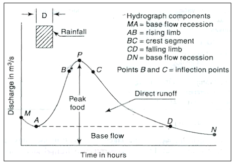
Hydrograph
- It is a graph showing the rate of discharge versus time in a river.
- Lag time: the time interval from the maximum rainfall to the peak discharge.

Distribution of flooding
- Type of regions: Alluvial plains, Deltaic segments of rivers
- Main regions: Mississippi and Missouri (U.S.A), Yangtze and Yellow (China), Irrawadi (Myanmar), Indus (Pakistan), Niger (Nigeria), Po (Italy), Euphrates and Tigris (Iraq) etc.
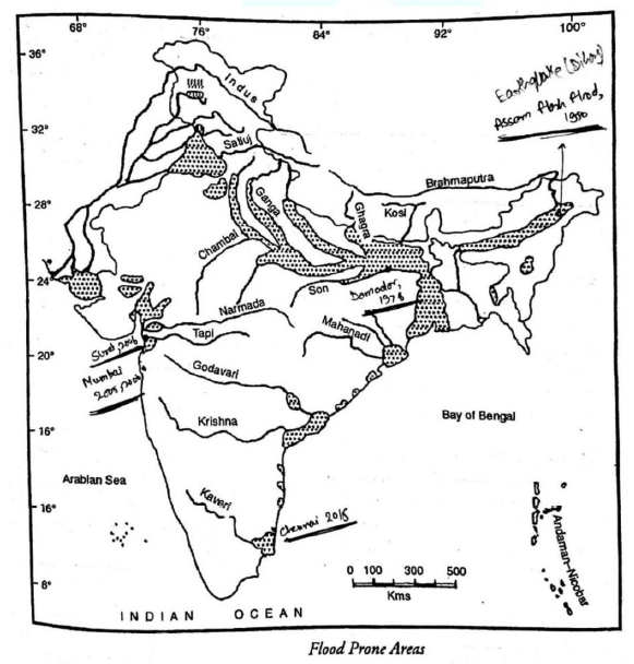
Flood Disaster in India (Source: National Commission on Floods)
- Bihar 24%
- Uttar Pradesh 24%
- Andhra Pradesh 15%
- West Bengal 7%
- Gujarat 6%
- Rajasthan 4.5%
Thinkers' Perspectives on Floods
1. Hydrological Processes
- Geographical thinkers emphasize the understanding of hydrological processes and their role in flood occurrence.
- They consider factors like precipitation patterns, river systems, and drainage networks to analyze flood events.
- For instance, by studying river morphology and flow patterns, geographers can identify areas prone to flooding during heavy rainfall events.
2. Environmental Determinism:
- This perspective suggests that floods are primarily determined by the physical environment and natural forces. It argues that human actions have limited influence on flood occurrences.
- According to environmental determinists, factors such as rainfall patterns, topography, and soil composition are the primary drivers of floods.
- Example: devastating floods in the Ganges-Brahmaputra-Meghna delta region are mainly a result of the region's low-lying topography and the heavy monsoon rains in the area.
3. Possibilism:
- Possibilism takes a more balanced stance, asserting that while the physical environment sets certain constraints, human agency and innovation play a crucial role in flood occurrences and management.
4. Man-Environment Interaction
- Human interventions, such as urbanization, deforestation, and land-use changes, can exacerbate flood risks.
- For example, deforestation in hilly areas can increase soil erosion and runoff, leading to higher flood probabilities downstream.
5. Radical Perspective:
- The radical perspective on floods emphasizes the role of social and political factors in exacerbating flood vulnerabilities and inequalities.
- It argues that floods disproportionately affect marginalized communities due to factors such as unequal access to resources, social structures, and economic disparities.
- Example: The radical perspective would critique the unequal distribution of flood protection measures in urban areas, where wealthier neighborhoods often receive more investment and protection, leaving poorer communities at a higher risk of flooding.
6. Marxist Perspective:
- The Marxist perspective examines floods through the lens of economic systems and class struggle, highlighting how capitalist modes of production contribute to flood vulnerabilities.
- It argues that profit-driven development practices, such as deforestation, urbanization, and inadequate infrastructure in pursuit of economic growth, increase the likelihood and impact of floods.
- Example: A Marxist analysis might point out how large-scale agricultural practices driven by profit motives, such as extensive irrigation or monoculture, can lead to soil degradation and increased flood susceptibility.
7. Spatial Analysis:
- The spatial analysis perspective examines floods from a geographical perspective, analyzing the spatial patterns and distribution of flood occurrences.
- It involves mapping flood-prone areas, studying the spatial distribution of flood damages, and identifying patterns in land use practices or settlement patterns that contribute to flood vulnerabilities.
Types of floods
1. Riverine floods
- Result of sustained rainfall, rapid snow melt, monsoons, or tropical cyclones.
- Localized flooding may be caused by drainage obstructions such as landslides, ice, debris, or beaver dams.
2. Areal floods
- Occurring due to heavy spell of rainfall.
- Mainly in low-lying areas, due to rainfall or snowmelt.
- Reasons: Surface soil saturates soon. Water table is usually shallow, such as in a floodplain.
- Infiltration is low due to frozen ground, rock, or concrete structure.
Examples:
- Frequent floods through Brahmaputra River.
- In arid regions: often clay-like soil, which has poor infiltration capacity. It greatly increases the amount of runoff.
- In Endorheic basins: precipitation exceeds evaporation.
- Note: Endorheic basins: these normally retain water and allows no outflow.
- Lower Damodar River floods, West Bengal- 1978: due to torrential cyclonic rainfall. The outflow of water increased from 10,000 cusecs to 100,000 cusecs in 24 hours. The lower catchment has alluvial plains. This high discharge of water could not be accommodated.
- Solution: Damodar river is a controlled river through a series of dams and reservoirs on the main river and its tributaries such as Panchet dam, Maithan dam, Konar dam, Tilaya dam etc. under the scheme of Damodar Valley Corporation (D.V.C).
- Mumbai floods, 2005: A spell of 24 hours of very heavy rainfall yielding rainfall of around 1000 mm.
- Surat floods, 2006: Torrential rainfall resulted in devastating floods. 200-year record was shattered.
3. Urban floods
- Urban flooding is the inundation of land in a built environment, particularly in densely populated areas.
- Reasons: surface run-off exceeds the local drainage capacity.
- Built environment, Paved streets and roads: reduce infiltration of rainwater significantly and increases surface runoff considerably
- Urban Heat Island Effect- Due to this, rainfall in and around urban areas has increased.
- An urban heat island is an urban area that is significantly warmer than its surrounding rural areas due to human activities.
- Inadequate solid waste management results in blocking of drains.
Case studies:
- Srinagar floods, 2014: Heavy and unexpected rainfall, choking of drains.
- Mumbai floods, 2005, 2006, 2019: Failure of local drainage capacity, and reclamation of CRZ. Encroachment of floodplains along the river Ulhas.
- Chennai floods, 2015: Encroachment in water bodies, reclamation of wetlands. In 2015, water was released from Chembarambakkam reservoir to Adyar River.
- Gurgaon floods, 2018: unplanned drainage system
- Assam floods: opening up of dams in upstream areas such as Arunachal Pradesh.
- Nasik floods: Inefficient management of religious gathering like Kumbh Mela.
- Delhi Flood 2023: Due to excessive rainfall and improper drainage. Encroachment of floodplains along the river Yamuna.
4. Coastal floods or Storm surge flooding
- Storm surge or tidal surge is an abnormal rise of water generated by a storm, over and above the predicted astronomical tides."
- Tsunami, tropical cyclones, storm surge.
- It is commonly associated with low pressure weather systems (such as in tropical cyclones).
Examples:
- The low-lying coast of the Bay of Bengal is particularly vulnerable to surges caused by tropical cyclones.
- The deadliest storm surge was the 1970 Bhola cyclone, Bay of Bengal.
- The deadliest storm surge in the twenty-first century was caused by the Cyclone Nargis, Myanmar- 2008.
5. Flash floods
- Flash floods are the rapid flooding events. The lag time from between rainfall and the onset of flooding is 2-4 hours (in hydrograph).
- Caused by heavy rain associated with a severe thunderstorm, hurricane, tropical storm, or meltwater from ice.
- Due to landslide, earthquake or volcanic eruption, Tsunamis.
- Due to collapse of a natural debris dam, or a human structure such as a man¬made dam.
- Recurrent floods at the same site: soil is already saturated.
- Localized convective precipitation (intense thunderstorms)
- Sudden release of water from an upstream dam or due to landslide, or glacier fall.
Case studies:
- Assam flash floods, 1950: due to Dihang earthquake.
- The Johnstown Flood, USA or the Great Flood of 1889: catastrophic failure of the South Fork Dam.
- Arid and semi-arid areas: flash floods because such areas have poor natural drainage systems. For example, unprecedented rainfall of 836 mm in 1981 & in and around Jaipur city, caused flash floods.
- Flash flood is the most common flood type in normally dry channels in arid zones. Eg. Rajasthan floods, 2019.
- Solution: Ghaggar River Diversion Scheme
Other Causes of Floods (Causative factors)
Deforestation (Upslope factor):
- Dense vegetation allows maximum infiltration of rainwater into the ground. Rain drops are intercepted by forest. These reach the ground slowly in the form of aerial streamlets through the leaves, branches and stems of trees.
- Deforestation decreases infiltration capacity of the land and consequently increases surface runoff.
- Also, the raindrops strike the ground surface directly, which increases the rate of soil erosion and thus increases the sediment load of the rivers, thus causes siltation of riverbeds.
- Examples: Large scale deforestation in Himalayas results flooding in the alluvial Ganga plains. (Ganga and its tributaries like Yamuna, Ramaganga, Gomti, Ghagra, Gandak, Buri Gandhak, Kosi etc.)
Meandering Courses of the Rivers (Downslope factor):
- Highly sinuous and meandering courses of the rivers obstruct the normal discharge of water. It delays the passage of water resulting into stagnation of water.
Climate change:
- Unusual monsoon.
- Change in spatial and temporal distribution of rainfall.
- Sea level rise.
Faulty Agricultural Practices:
- Cultivation of valley-side slopes reduces the gradient of river-banks.
- It flattens the valley. Hence, the river takes very little time in attaining its bankfull capacity.
Effects
There is constant increase in the frequency, intensity, spatial coverages and magnitude of floods in India.
Primary effects:
- Loss of life of human and farm animals.
- Damage power transmission and sometimes power generation infrastructure.
- Loss of drinking water treatment and water supply, which may result in severe water contamination.
- Loss of sewage disposal facilities.
- Risk of waterborne diseases like typhoid and cholera.
- Damage to roads and transport infrastructure may make it difficult to mobilize emergency health treatment.
- Loss of harvests.
Secondary effects:
- Economic hardship due to a temporary decline in tourism, rebuilding costs, or food shortages leading to price increases.
- Psychological damage, serious injuries and loss of property occur.
- Urban flooding can cause chronically wet houses, leading to the growth of indoor mold. Resulting in adverse health effects.
Benefits:
- Periodic flooding was essential to the well-being of ancient communities. Like along the Tigris-Euphrates Rivers, Nile, Indus, Ganges and the Yellow River.
- Floods make soil more fertile and increasing nutrients in soils.
- Recharging ground water.
- Filling of reservoirs in arid and semi-arid regions.
- Key factor in maintaining floodplain biodiversity.
- Some fish species make use of floods in order to reach new habitats.
- Rise in bird populations due to boost in food production caused by flooding.
- Balancing the full food web.
Remedial Measures / Management of Flood Disaster
Floods are natural phenomenon and one cannot entirely get rid off them.
A. Pre-disaster stage:
1. Preparedness (P):
- Planning and organizing: Developing comprehensive flood management plans, including early warning systems, evacuation routes, and communication strategies.
- Training and capacity building: Educating and training relevant stakeholders such as emergency response teams, local communities, and government agencies on flood response protocols and procedures.
- Resource allocation: Identifying and procuring necessary resources like equipment, emergency supplies, and manpower to be deployed during floods.
- Public awareness campaigns: Conducting awareness programs to educate the public about flood risks, safety measures, and evacuation procedures.
- Example: Conducting mock drills in flood-prone areas to test the effectiveness of the emergency response system and improve preparedness.
Status in India: Flood Forecasts and Early Warning System (EWS)
- Institutions: Central Flood Control Board (established 1954) and the State Flood Control Boards.
- Flood forecasting and Early warning system is well organized in India. Flood warning messages are communicated in time through electronic and print media.
- But the social constraints create hinderance in the evacuation plan because people are always scared of theft of property.
2. Mitigation (M):
- Structural measures: Constructing flood control infrastructure such as dams, levees, embankments, and flood channels to reduce the impact of flooding.
- Non-structural measures: Implementing land-use planning, zoning regulations, and building codes to prevent construction in flood-prone areas.
- Ecosystem-based approaches: Restoring and preserving natural floodplains, wetlands, and forests that act as natural buffers against floods.
- Example: Implementing a floodplain zoning policy that restricts the construction of residential buildings in high-risk areas, reducing potential flood damage.
3. Prevention (P):
- Drainage management: Regular maintenance and cleaning of drains, canals, and waterways to ensure efficient water flow and reduce the risk of blockages during floods.
- Flood forecasting and monitoring: Establishing monitoring systems to track rainfall patterns, river levels, and weather forecasts, enabling early prediction and warning of potential floods.
- Climate change adaptation: Assessing the impact of climate change on flood risk and implementing adaptation strategies such as improving urban drainage systems or elevating infrastructure.
- Example: Installing flood gauges and automated weather stations along rivers to monitor water levels and rainfall, providing real-time data for flood prediction and prevention.
Some Case Studies of Prevention:
(1) Delay the Runoff:
- Man cannot stop high intensity rainfall. Man can only delay the return of surface runoff (Possibilism).
- This can be achieved by large-scale afforestation in the hilly source catchment areas.
(2) Hasten the Discharge of River Water:
- Meander loops in the highly sinuous and meandering rivers retard the quick disposal of water.
- Straighten the meandering courses of the rivers by artificial cutoffs.
- Issues: i) huge money ii) meandering is a natural process of alluvial rivers. Rivers may develop meanders at other places.
- For Example, the Mississippi river was shortened in its length from 530 km to 185 km near Greenville (U.S.A). Similarly, Missouri river (U.S.A) was shortened in its length by 50 km.
(3) Reduce the Volume of Water:
- Through a series of engineering devices such as construction of flood-control storage reservoirs.
Examples:
- Miami river in Ohio (USA) in 1913: very effective.
- Tennessee Valley Authority (TVA), 1933: not only controlled the recurrent floods and tamed the mad Tennessee river but has entirely changed the socio¬economic picture of the basin.
- Damodar Valley Corporation (DVC): a multi-purpose river project on the line of TVA.
- Four dams namely Konar, Maithan, Panchet Hill and Tilaiya have been constructed on the Damodar River and its tributaries (Barakar and Konar rivers).
- Besides flood control, the DVC also generates hydroelectricity and provides water for irrigational purposes.
- Ukai Reservoir on the Tapi river: It has almost saved the lower reaches of the river and the town of Surat from the disaster of flood hazards.
(4) Divert the Flood Water:
- Diversion of flood water in lowlying areas, depressions or artificially constructed channels.
- For example: Ghaggar River Diversion Scheme diverts the water discharge of about 300-400 cumecs into the depressions and in sand dunes before entering Rajasthan.
(5) Engineering solutions:
(a) Embankments, dikes and flood walls are used to confine the flood water within a narrow channel.
- For example: Flood Control Embankments at Bagmati, Mahnanda, and Kosi Rivers.
- Kosi embankments (Approx. 250 km) checked the westward shifting of the Kosi river. Before this construction, Kosi River shifted its course westwards by about 110 km.
- But any breaches of such dikes result into more disastrous floods than natural floods. For example; dike failures in The Great Flood of Hwang Ho, 1887.
(b) Stone spurs: e.g. Dibrugarh Town Protection Scheme: stone spurs, semi-permeable spurs and protective dikes constructed to protect the town from the Brahmaputra floods.
(c) Shifting of outfall of rivers: eg. Jalpaiguri Town Protection Works: the Karala river into Teesta river.
B. Disaster stage:
1. Rescue operation (R):
- Evacuation and search-and-rescue: Swiftly evacuating affected populations to safer areas and conducting rescue operations to save people stranded in flooded regions.
- Emergency medical assistance: Providing immediate medical aid and setting up medical camps to treat injuries, waterborne diseases, and other health emergencies.
- Temporary shelter and essential services: Establishing temporary shelters, distributing relief materials like food, water, and medicines, and ensuring access to basic amenities.
- Example: Deploying trained personnel and specialized equipment, such as boats and helicopters, for rescue operations in flooded areas, prioritizing the rescue of vulnerable individuals like children, elderly, and disabled.
C. Post-disaster stage:
1. Relief (R):
- Immediate assistance: Providing emergency relief supplies, including food, water, clothing, and hygiene kits.
- Temporary housing and infrastructure restoration: Setting up temporary shelters and restoring essential infrastructure like roads, bridges, power supply, and water systems.
- Psychosocial support: Offering counseling and mental health support to individuals and communities affected by the flood to help them cope with trauma and emotional distress.
- Example: Distributing relief packages containing essential items to displaced families and establishing community kitchens to provide cooked meals to those in need.
2. Recovery (R):
- Damage assessment: Conducting detailed assessments of infrastructure damage, economic losses, and impacts on livelihoods to inform recovery plans.
- Reconstruction and rehabilitation: Initiating long-term reconstruction efforts to rebuild damaged infrastructure, houses, schools, hospitals, and other public facilities.
- Livelihood restoration: Implementing programs to restore livelihoods by providing financial assistance, vocational training, and support for small businesses and farmers.
- Example: Offering low-interest loans and grants to affected businesses to help them recover and restart their operations, enabling economic revival.
3. Rehabilitation (R):
- Infrastructure improvement: Implementing measures to enhance resilience against future floods, such as strengthening embankments, improving drainage systems, and upgrading flood warning systems.
- Community-based initiatives: Encouraging community participation in flood management, establishing local disaster management committees, and promoting community resilience and preparedness.
- Policy and governance reforms: Reviewing existing policies and regulations related to flood management and incorporating lessons learned from the disaster to improve future response and prevention.
- Example: Conducting workshops and training programs to empower local communities with knowledge and skills in flood-resistant construction practices and sustainable land management techniques.
NDMA Guidelines on Management of Flood
- Shifting the focus to preparedness by implementing Flood Management Plans.
- Ensuring regular monitoring
- Continuous modernization of flood forecasting and early warning systems.
- Flood resistant features in the design and construction.
- Time-bound plans for the flood proofing of strategic and public utility structures.
- Improving awareness and preparedness.
- Capacity building measures: including education, training, research and development, and documentation.
- Improving the compliance through penalty measures.
NDMA Guidelines on Urban Flooding
- Create a National Hydro-meteorological Network for providing early warning in all urban centers.
- Use of Doppler Weather Radars in all urban areas.
- An inventory of the existing storm water drainage system to be prepared. The inventory will be both watershed based and ward based.
- Watershed and Catchment to be the basis for planning the drainage systems.
- Rainwater harvesting as an integral component of the building utility.
- Low-lying areas have to be reserved for parks and other low-impact human activities.
- Penal action on encroachments on the drain.
- Pre-monsoon desilting of all major drains to be completed by March 31 each year.
- Urban Flooding has to be dealt as a separate disaster. It should be delinked from riverine floods, which affect the rural areas.
- Suitable interventions in the drainage system to reduce the solid waste discharge.
- Inlets on the roads to drain water to the roadside drains.
- Concept of Rain Gardens in planning for public parks and on-site storm water management for larger colonies.
- Flood hazard assessments based on projected intensities and duration of rainfall and land use changes.